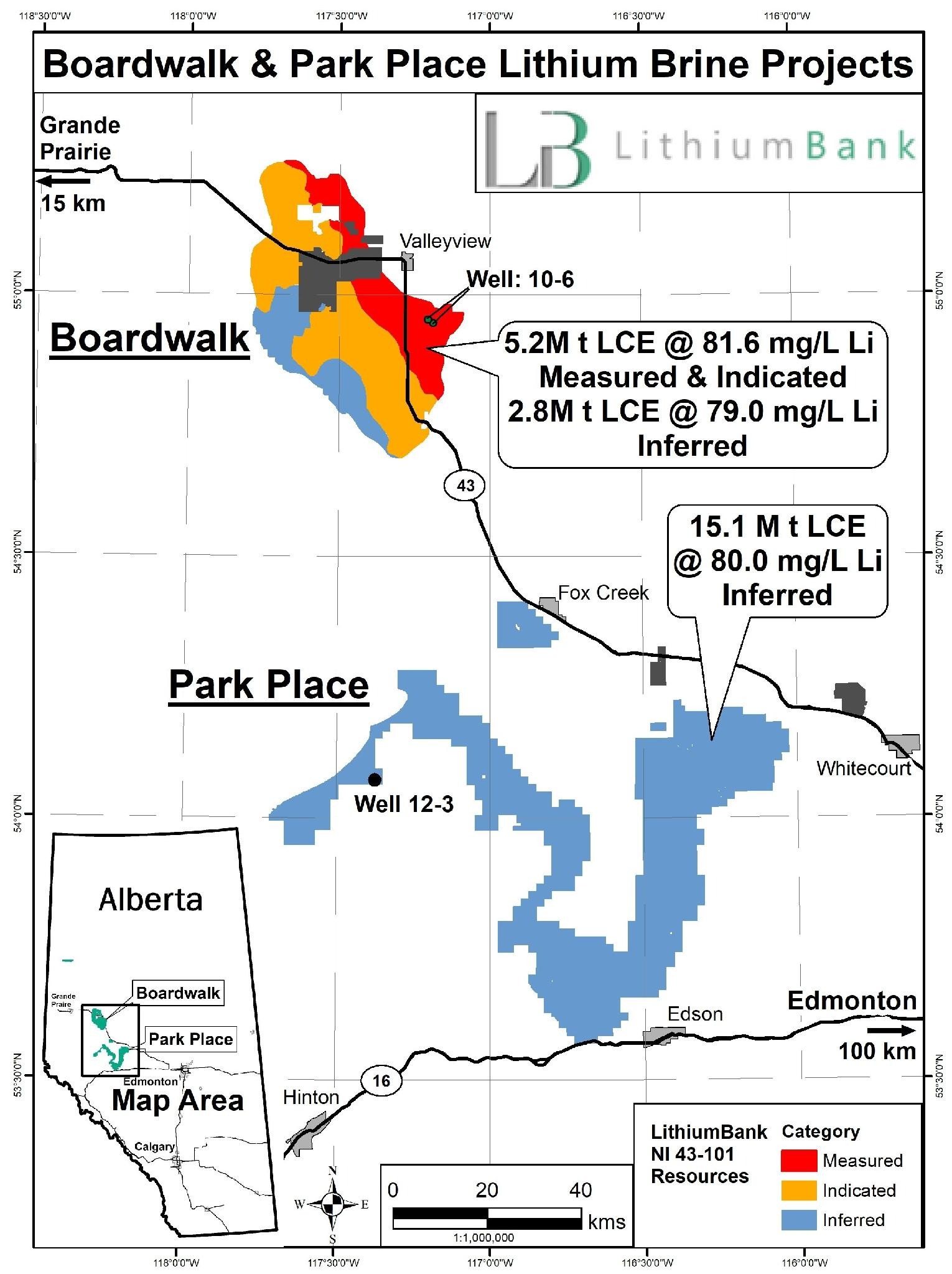
Park Place
LithiumBank’s 100%-owned Park Place Project is one of the largest undeveloped lithium-brine assets in North America, strategically located in west-central Alberta within a mature energy-producing region with extensive infrastructure and year-round access. The project is positioned to benefit from Alberta’s regulatory environment, oilfield infrastructure, and a skilled workforce, providing a strong foundation for efficient future development.
Park Place hosts an inferred mineral resource of 15.1 million tonnes lithium carbonate equivalent (“LCE”) with an average lithium concentration of 80.0 mg/L, making it one of the largest reported lithium-brine resources in Canada. The project targets the Devonian-aged Leduc and Swan Hills formations, both of which are well understood through decades of historic oil and gas production and extensive subsurface data. Reservoir continuity and deliverability are supported by more than 450 historical wells, 3D and 2D seismic coverage, and multiple lithium-brine analyses across the project area.
The effective date of the Park Place mineral resource estimate is June 24, 2024.
Park Place Updated NI 43-101 Resource Estimate
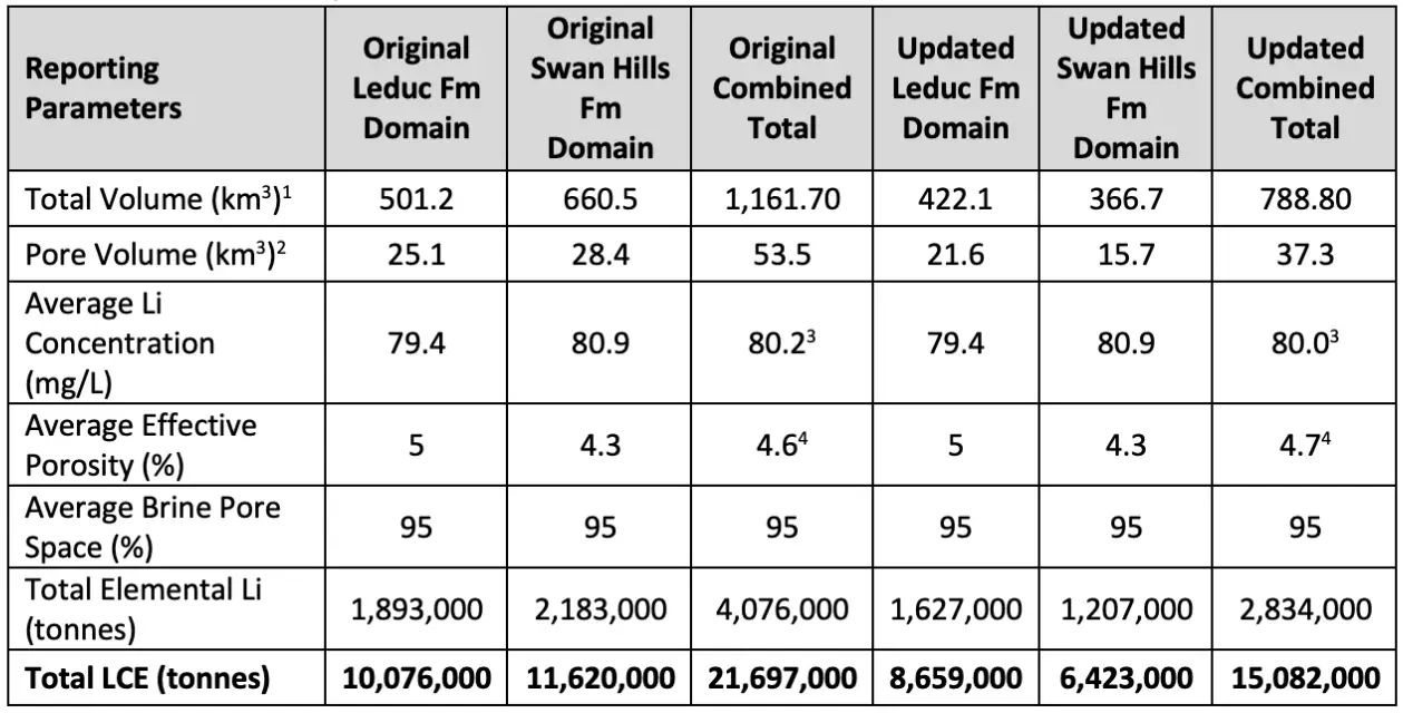
1. Total volume of rock and pore space
2. Total volume of effective porosity
3. Calculated using a weighted average (by pore volume) from the average grade of the Leduc and Swan Hills formations
4. Calculated using a weighted average porosity by total formation volume for both Leduc and Swan Hills formations
Notes
1: Mineral resources are not mineral reserves and do not have demonstrated economic viability. There is no guarantee that all or any part of the mineral resource will ever be upgraded to a higher category. The estimate of mineral resources may be materially affected by geology, environment, permitting, legal, title, taxation, socio-political, marketing, or other relevant issues.
2: The weights are reported in metric tonnes (1,000 kg or 2,204.6 lbs).
3: Tonnage numbers are rounded to the nearest 1,000 unit.
4: In a 'confined' aquifer (as reported herein), effective porosity is an appropriate parameter to use for the resource estimate.
5: The resource estimation was completed and reported using a cut-off of 50 mg/L Li.
6: To describe the resource in terms of industry standard, a conversion factor of 5.323 is used to convert elemental Li to Li2CO3, or Lithium Carbonate Equivalent (LCE).
7. The technical report entitled “LithiumBank Resources Crop. Park Place NI 43-101 Technical Report” dated effective June 24, 2024 is available on SEDAR+.
The project spans approximately 538,000 contiguous acres of Crown mineral licenses with no freehold royalties or carbon sequestration overlap, simplifying future development planning and reducing potential land-use conflicts.
LithiumBank has also demonstrated strong technical results at Park Place through Direct Lithium Extraction (“DLE”) pilot testing conducted with SLB. Recent testing achieved approximately 95% lithium recovery and greater than 99% impurity rejection at pilot scale. The Company believes these results support the potential suitability of the project’s brine chemistry for modern DLE processing technologies designed to produce battery-grade lithium products with a smaller environmental footprint than conventional evaporation methods.
As LithiumBank advances Boardwalk toward commercial production, Park Place represents a significant long-term development asset within the Company’s portfolio and provides additional scalability to support future North American critical mineral supply chains.